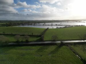
Somerset County Council has closed the A361 across the Somerset Levels following warnings from the Environment Agency (EA) that floodwaters are likely to spill onto the road.
Road users are being urged to plan ahead and use an alternative route from 6pm this evening (Tuesday 10 January) from when the emergency road closure gates at Burrowbridge and East Lyng will be closed.
Currymoor, one of the largest flood storage reservoirs on the Somerset Levels and Moors, is expected to become full this evening. When this happens, excess water will be conveyed down a spillway into the next storage reservoirs at Northmoor and Saltmoor, which are currently empty. However, this creates a flood risk to the A361, with a high chance of water getting onto the road. As a precaution, the council has put in place a pre-emptive road closure.
A yellow weather warning for rain will be in place from 9pm tonight (Wednesday) to 6pm Thursday and a flood warning remains in place for Currymoor and Haymoor. This means it is increasingly likely the road will need to remain closed for several days.
Following 2014, emergency road closure gates were installed at eight locations, including between Burrowbridge and East Lyng on the A361, to prevent vehicles getting stuck in flood waters.
Local residents and businesses are being kept informed.
Somerset County Council’s Lead Member for Highways and Digital Cllr Mike Rigby said: “We are clear that we have to put people’s safety first and following warnings from the EA it is essential that we close the A361 if flooding is forecast.
“We’d urge people to please plan ahead and then to check our social media and local media for updates. It’s highly likely the A361 will need to close for a number of days.
“We understand this will be a concern to people and may cause some inconvenience but we have to ensure the safety of road users. That unfortunately means the road must remain closed until we have carried out stringent safety checks.”
The Environment Agency is monitoring the situation and using all available opportunities to reduce the water level of Currymoor. In the meantime, it urges motorists not to drive through flood water. Just 30cm of moving water is enough to float a car, and by driving through flood water, drivers open themselves up to the risk of being swept away and having to be rescued or getting stranded after their car engine takes in water and stops.
D-J Gent of the Environment Agency said: “The sight of the A361 closed because of flooding will no doubt bring back memories of the flooding in 2013/14. However, this situation is very different. Considerable investment and working with partners including the Somerset Rivers Authority has been made in making Somerset more resilient, the rainfall has not been as severe and there have been windows of opportunity to pump the water levels down in our storage areas.
“Additional pumps can be deployed to keep water levels low at Northmoor and Saltmoor while we reduce the level of Currymoor. Once Currymoor’s water level reduces, then the Athelney spillway will stop running and no more water will flow to the A361 or Saltmoor floodplain.”
You can see if emergency road closure gates are open or closed at https://www.travelsomerset.co.uk/roadclosuregates and get travel updates from @TravelSomerset.
Check your flood risk at https://check-for-flooding.service.gov.uk.


